How Virtual Landscape Design Actually Works: The Science Behind the Screen

The Myth of the "Mandatory Site Visit"
For decades, the prevailing wisdom in landscape design dictated that a designer must be physically present on-site to truly understand a property. This belief, while rooted in traditional practices, often overlooks the limitations of the human eye and the vast advancements in data collection technology. A physical walk-through, while offering a general feel for a space, can easily miss crucial, underlying environmental factors that dictate a landscape's long-term success.
What the naked eye misses that satellites catch.
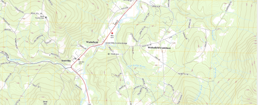
Consider the complexities of a landscape: historical drainage patterns, precise solar angles throughout the year, subtle shifts in elevation, and microclimates. These elements are often invisible or difficult to accurately assess during a brief site visit. Satellites, however, capture comprehensive data, providing an objective and detailed understanding of these critical factors. Geographic Information Systems (GIS) can process this data to reveal insights that no amount of walking or visual inspection could uncover, offering a more robust foundation for design decisions [1]. Furthermore, tools like SunCalc show precise sun angles, seasonal light exposure, and shadow movement throughout the year. This is vital for optimizing plant placement, designing comfortable outdoor living spaces, and understanding how light will interact with architectural elements.
Data Collection: How We Map Your Land from Miles Away
At Williston Horticulture & Design, our remote process is a sophisticated blend of client collaboration and cutting-edge data analysis. We don't just rely on pretty pictures; we look deep into the science of your specific site.
Client intake vs. advanced mapping tools.
The initial phase involves a detailed client intake, where homeowners provide photographs, videos, and measurements of their property. This personal input is invaluable for understanding aesthetic preferences and functional needs. However, this qualitative data is then rigorously cross-referenced and augmented with quantitative data from advanced mapping tools. For precise base mapping, we utilize AutoCAD, an industry-standard software that allows us to create accurate, scalable drawings of your property, incorporating all existing features, structures, and utilities. For initial site reconnaissance and a bird's-eye view, Google Earth Pro is an invaluable resource. It helps us collect aerial imagery, measure distances and areas, study topography and slope, and understand how the site relates to its surroundings, identifying opportunities or constraints early in the design process [2]. This dual approach ensures that every design decision is informed by both your vision and the undeniable realities of your land.
The Soil Does Not Lie: Engineering the Subterranean Layer
The foundation of any thriving landscape lies beneath the surface of the soil. Understanding its composition, pH, and nutrient levels is paramount for selecting plants that will flourish, not just survive.
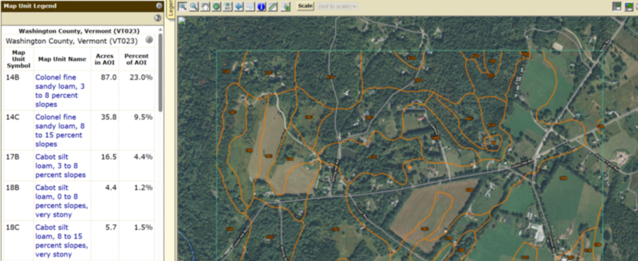
Using the Web Soil Survey.
We utilize the Web Soil Survey, a comprehensive online database provided by the United States Department of Agriculture (USDA), to access detailed soil information specific to your zip code [3]. This tool allows us to understand the soil type, drainage characteristics, and other vital properties without ever touching the dirt. This scientific approach ensures that our plant selections are perfectly matched to your subterranean environment, promoting robust growth and minimizing the need for excessive amendments or interventions.
From Raw Data to the Masterplan
Once all the data is meticulously collected and analyzed, our expert designers translate this information into a comprehensive masterplan. This isn't just about creating a visually appealing rendering; it's about engineering a sustainable ecosystem.
Why we reject AI templates for real horticultural science.
In an era of instant gratification, many services offer AI-generated templates for landscape design. While these might provide a quick visual, they fundamentally lack the nuanced understanding of horticultural science required for long-term success. At Williston Horticulture & Design, we firmly reject this templated approach. Our designs are bespoke, crafted by experienced professionals who integrate ecological principles, plant pathology, and regional climate data to create landscapes that are not only beautiful but also resilient and ecologically sound. We prioritize the science of survival over the fleeting appeal of a generic digital mockup.
FAQ: Understanding the Remote Design Process
Can ChatGPT design landscape?
While AI tools like ChatGPT can generate conceptual images or textual descriptions of landscapes, they lack the capacity for true ecological engineering. They can create a picture, but they cannot analyze soil data, understand complex drainage patterns, or select plants based on their specific needs within a unique microclimate to engineer a surviving ecosystem. Human expertise remains indispensable for creating truly sustainable and thriving outdoor spaces.
Is there a free online landscape design tool?
Yes, numerous free online tools exist for landscape design. These platforms are excellent for visualizing ideas, experimenting with layouts, and getting a general sense of aesthetic possibilities. However, they are primarily for visualization and do not offer the in-depth scientific analysis or ecological planning necessary for functional, long-term landscape success. They serve as a starting point, not a comprehensive solution for ecologically sound design.
The best tool in landscape design isn't a shovel, it's accurate data. At Williston Horticulture & Design, we harness the power of advanced technology and scientific understanding to create landscapes that are not only stunning but also sustainable, resilient, and perfectly adapted to their environment. Our remote process ensures that geographical distance is no barrier to achieving your dream garden, grounded in the undeniable truths of science.